Hurricanes in Georgia
When is Hurricane Season in Georgia?
The official hurricane season in Georgia extends from June 1st to November 30th, coinciding with the Atlantic hurricane season, according to the National Oceanic and Atmospheric Administration.
Georgia experiences less frequent hurricanes compared to other coastal states. The National Hurricane Center records indicate that Georgia has been directly hit by a major hurricane only once in the past century, with most events classified as a tropical depression or weaker.
However, according to the Georgia Emergency Management and Homeland Security Agency, the Peach State is still susceptible to significant impacts from tropical storm remnants and systems that make landfall along the Gulf Coast or Southeast Coast.
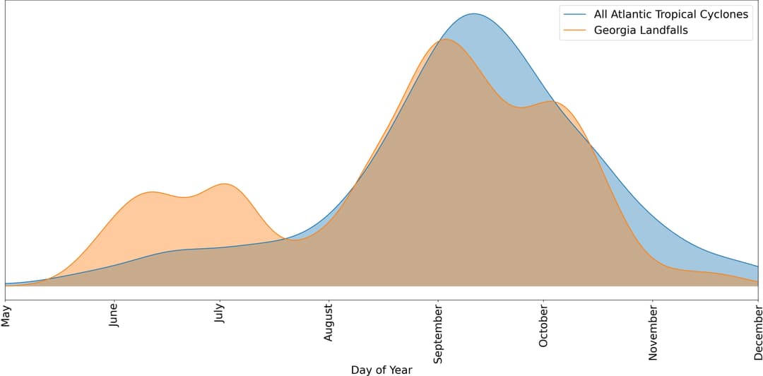
Our team has produced an image that illustrates the likelihood of Georgia experiencing a tropical cyclone on any given day of the year based on data tracing back to 1851.

The graph contrasts the actual storm landfalls in Georgia with the broader storm patterns observed throughout the Atlantic basin. The visualization uses raw data from the NOAA Hurricane Research Division.
Where Do Hurricanes Hit Most in Georgia?
In Georgia, hurricanes primarily affect the coastal regions, particularly the Southeastern part. These areas, which include cities such as Savannah and Brunswick, often bear the brunt of hurricane-force winds, floods, and storm surges.
Inland, the impact of hurricanes tends to diminish, but areas in the Southern part of Georgia can still experience significant effects, particularly from heavy rainfall leading to flood conditions. Cities like Albany and Valdosta, despite being inland, have experienced substantial damage from hurricanes in the past. Some of the worst damage in the past decades has come from inland flooding along rivers after hurricanes move ashore.
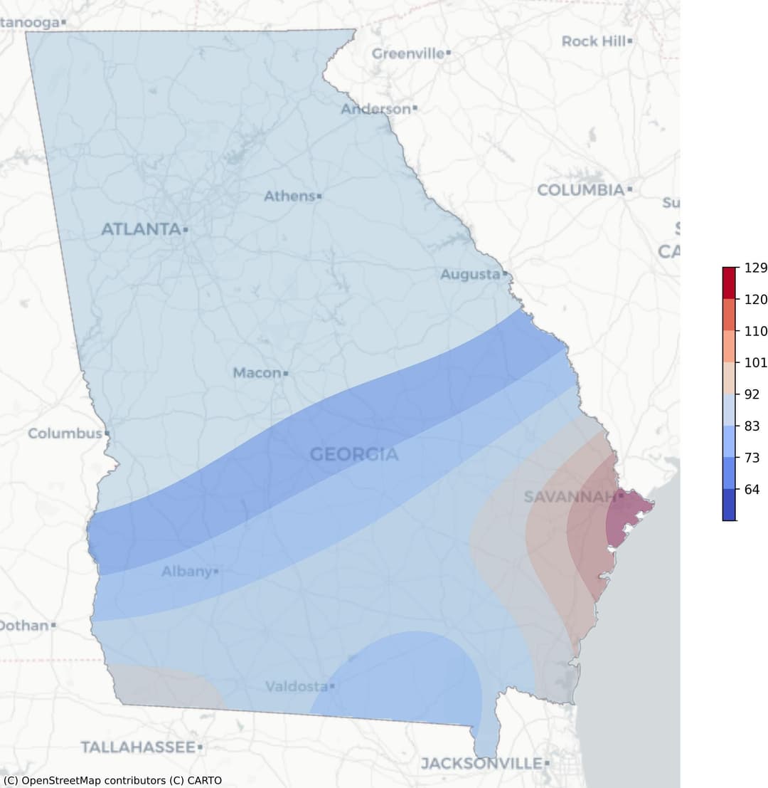
The following representation, [[HURRICANE_RISK_GRAPH]], illustrates the hurricane risk heat map for Georgia. The frequency of occurrence weighted by wind speed is displayed as a graduated color map from blue to red. In this graph, blue indicates areas with the lowest risk, while red denotes the highest.

As the graph shows, the Southeastern coastal region of Georgia exhibits a stronger red coloration, indicating a higher risk of hurricanes. This is due to the proximity to the Atlantic Ocean, which is a breeding ground for these storms. The intensity of the color gradually fades to blue as we move further inland, demonstrating the decreasing risk of hurricane-force winds.
While the graph is a valuable tool for visualizing risk, it's essential to remember that hurricanes are unpredictable and can cause damage in areas not typically prone to such events. Therefore, preparedness is crucial, regardless of where in Georgia one resides.
What Are the Recent Hurricanes in Georgia?
- Hurricane Michael (2018): This catastrophic hurricane caused a direct death in Georgia near Lake Seminole, Seminole County. The southeastern United States experienced significant damage, with Georgia bearing a cost of around $4.7 billion. Several counties, including Dougherty and Seminole, reported extensive damage to homes, agriculture, and forestry.
- Hurricane Matthew (2016): Georgia was significantly affected by Matthew's high winds and rain, causing two direct fatalities in Statesboro and Savannah, as people were killed when trees fell on their homes. Widespread wind damage affected roofs, downed trees, and utility lines. More than 12 inches of rainfall led to freshwater flooding over 4 ft deep in some locations. Matthew was the tenth most destructive hurricane to affect the United States, causing an estimated damage of over $10 billion.
How to Prepare for a Hurricane Season in Georgia
Preparation for a hurricane season is paramount, particularly for states like Georgia that are susceptible to such natural disasters. Proper readiness significantly reduces the risk of property damage and helps ensure the safety and well-being of residents. Before a Hurricane
Implementing a hurricane preparedness plan is crucial to ensure safety during a storm. Here is a brief hurricane preparation checklist to consider:
- Start by creating a disaster plan. Include details on how to evacuate, where to go, and how to communicate with family members.
- Assemble a disaster supplies kit, including food, water, medications, important documents, and other essentials.
- Secure your home. Install storm shutters or board up windows, clear rain gutters, and reinforce the roof, doors, and garage.
- Stay informed about the hurricane's path and updates from local authorities.
- Know your community's hurricane safety plan, including understanding the evacuation routes and locations of emergency shelters.
- Check your insurance coverage to ensure it covers damages caused by hurricanes.
- Protect your electronics and appliances by unplugging them and moving them to higher ground if possible.
This list is not exhaustive, but it serves as a starting point for preparing for a hurricane. Always remember that your safety and the safety of your loved ones should be the priority.
During a Hurricane
Here is a list of actions to ensure safety during a hurricane:
- Stay informed: Monitor weather updates and listen to the instructions of local officials.
- Seek shelter: If an evacuation is not ordered, secure your home and stay inside.
- Stay away from windows: Hurricanes can send debris flying at high speeds. It's safer to stay in an interior room without windows.
- Don't use electrical appliances: Power surges during hurricanes can damage appliances and potentially cause electrical shocks.
- Keep a disaster supplies kit: This should include water, non-perishable food, medicine, flashlights, and batteries.
- Don't drive: Unless evacuating, avoid driving, as roads may be blocked or flooded.
After a Hurricane
When a hurricane has passed, the recovery process can be overwhelming. Here is a list of steps to guide you through what to do after a hurricane:
- Ensure safety: Verify the safety of all family members. Check your surroundings for potential hazards such as downed power lines or gas leaks.
- Document damage: Capture photographs or videos of the damage caused to your property. This will serve as crucial evidence when you file an insurance claim.
- Contact insurance: Notify your insurance company about the damage. Provide them with the necessary documentation to support your claim.
- Reach out to FEMA: The Federal Emergency Management Agency (FEMA) offers disaster assistance. Apply for help online or by phone as soon as you can.
- Start clean-up: Begin cleaning and repairing your property once it's safe to do so. Be cautious of potential structural damage.
- Seek professional help: Depending on the extent of damage, you might need to hire professionals for repair and restoration.
- Stay informed: Follow local news and updates for information about aid, resources, and recovery efforts in your area.